Mount Fuji is located in Japan on an island called Honshu Island. Mount Fuji is the tallest mountain in Japan at 3,776.24 meters (12,389 ft). Just like Mount St. Helens, this mountain is also a stratovolcano. I learned that Mount Fuji was formed by a subduction zone. When the more dense plate pushed rock deeper into the earths mantle, the stone melted into magma. Throughout time, this magma has risen to the surface forming a mountain as well as a volcano known as Mount Fuji. Although, legend says that this mountain was formed by an earthquake. The guide told me that this mountain is about 200,000 years old. So this geologic landform is only from the Quaternary Period in the Cenozoic Era. This mountain's nearly perfect shape makes it a great attraction. Especially on clear days!
http://upload.wikimedia.org/wikipedia/commons/2/2a/01_Fujisan_from_Yamanakako_2004-2-7.jpg
Wednesday, March 6, 2013
Tuesday, March 5, 2013
Dead Sea (Jordan)
The Dead Sea located in Jordan was a really fun place to visit. Since the Dead Sea has 33% salt content, this makes you very buoyant so I loved to lay on top of the water! Another result of all this salt is that no life at all, plants and animals, can survive within these waters. Hence the name, Dead Sea. I learned that this location formed over a very long time from the evaporation of nearby waterways and bodies of water that contributed to the additional adding of salt to the waters. The guide had told me that the Dead Sea is about three million years old. This means that the sea is from the late Neogene geological period. If you wish to visit this location, my number one tip is to never try to taste the water there. I learned the hard way. It is super bitter.

http://cdn.enjoyourholiday.com/wp-content/uploads/2012/03/Dead-sea.jpg
http://www.bing.com/images/search?q=dead+sea&qpvt=dead+sea&FORM=IGRE#view=detail&id=98DD74EEA2452963F21BEA532CA21543E56F0A59&selectedIndex=19
Angel Falls (Venezuela)
Angel Falls was one of my favorite locations to visit! The height of these falls is 979 meters (3,212 ft) along with a significant plunge of 807 meters (2,648 ft). The guide explained to me how these falls had been formed. he said that from where the water drops off the the top off the falls to where it drops into the river to keep flowing was most likely the result of a fault. Then after awhile of changes in river direction and rainfall as well as other natural changes, water soon started to form a river going over the fault to form the falls. I also learned that Angel Falls is so recent that it was formed in 1680 or 221 years ago! After awhile of thinking and seeing this natural wonder, I thought to myself why it was given the name that it was given. The guide told me that since Jimmie Angel was the first US aviator to fly over the falls, this location had been named after him. Hence the name, Angel Falls. There are a wide range of ways to experience this geologically significant location ranging from on foot expedition, to rafting, to riding a helicopter to see an overview of the falls. Trust me, you will not regret visiting this location!
http://en.wikipedia.org/wiki/File:SaltoAngel4.jpg
Monday, March 4, 2013
Copper Canyon (Mexico)
Copper Canyon in Mexico is a great place to travel to and is also right next to the American border. This mountainous location has many great views, angles, and sights to see. The guide told me that the canyon had been formed by the slow uplift of volcanic rock was happening throughout the region while six different river systems were weathering and eroding away at these uplifts in the canyon. That is what makes today's unique shapes and mountains within the Copper Canyon. I learned that this geologically significant location had been formed about 30-40 million years ago! This means that the canyon was formed during the middle Paleogene Period within the Cenozoic Era. The guide had also taught me that since the canyon has all of the rivers running through it, it tends to be very green with life such as oxidized copper is, green. This is why the canyon has the name that it is given. If you wish to visit this region, you can also visit towns that are located within the canyon and experience life there as it tends to move considerably slower. Of course, don't forget a camera.
http://geo-mexico.com/wp-content/uploads/2010/08/copper-canyon-2.jpg
Mount St. Helens (Washington)
Mount St. Helens is a still active stratovolcano that is located in Washington state. St. Helens is simply a mountain as well as an active volcano. As a result, the top of the mountain is indented or taken off most likely as a result of past eruptions blowing of the top part of the mountain. The guide had explained to me that this mountain is formed as a result of Juan De Fuca tectonic plate being subducted under the North American plate. As the Fuca plate gets subducted deeper into the earth, it melts and this magma starts rising towards the crust forming the mountain and possibly an eruption. I learned that this stratovolcano is only about 40,000 years old so it is fairly young and was formed during the Quaternary Period during the late Cenozoic Era. This location remains one of the most popular natural laboratories for studying the earth and remains the most active volcano in the Cascade Range. Visiting this region has some great views and was and is a great experience.
http://wwgallery/full/611/1685611.jpg
w.outdoorphotographer.com/images/
http://wwgallery/full/611/1685611.jpg
w.outdoorphotographer.com/images/
Death Valley (California)
Death Valley located in Eastern California is one of the hottest and most arid places in the country. This location is about 3,ooo square miles (7,800 sq km). I was told by the guide that starting in the early Cenozoic Era, this landscape went through a time where basically nothing happened. No igneous or sedimentary rocks were know around this area and no significant even were happening here. After this time of "nothingness", the desert landscape had been formed by a long time of everything have been eroded away into nothing. Today all you see is sand dry areas with cracking at the surface. Therefore, this region had been around since the Paleogene Period. Death Valley holds the record for the highest recorded temperature in the world which is 134 degrees Fahrenheit (56.7 degrees Celsius). If you wish to visit this location of low relief, make sure to d dress lightly and to stay hydrated!
http://www.bing.com/images/search?q=death+valley+california&qpvt=death+valley+california&FORM=IGRE#view=detail&id=1668D8801490152063834EAE9C983B6B96160A0A&selectedIndex=20
Friday, March 1, 2013
Grand Canyon (Arizona)
Grand Canyon, located in northwest Arizona covering 277 miles (446 km) in length, 18 miles (29 km) in width, and is over one mile (6,000 ft/ 1,800 meters) in depth. You can experience the natural wonders of this location by experiencing its mountainous views to rafting the
Colorado River. The guide had explained to me that starting 5 to 6 millon years ago, the canyon had been carved out by the Colorado river. Through this time, the river had formed the canyons various and unique dips and crevices. I had been told that this canyon had always been said to be 6 million years old untill recent studies which suggests about a 16 to 17 million years old which would have both been durng Cenozoic Era. There is still much to figure out and to learn from this unique land region. If you wish to visit this location, be sure to bring a camera to capture the moments and to take the skywalk to get an amazing view over this amazing landscape region.
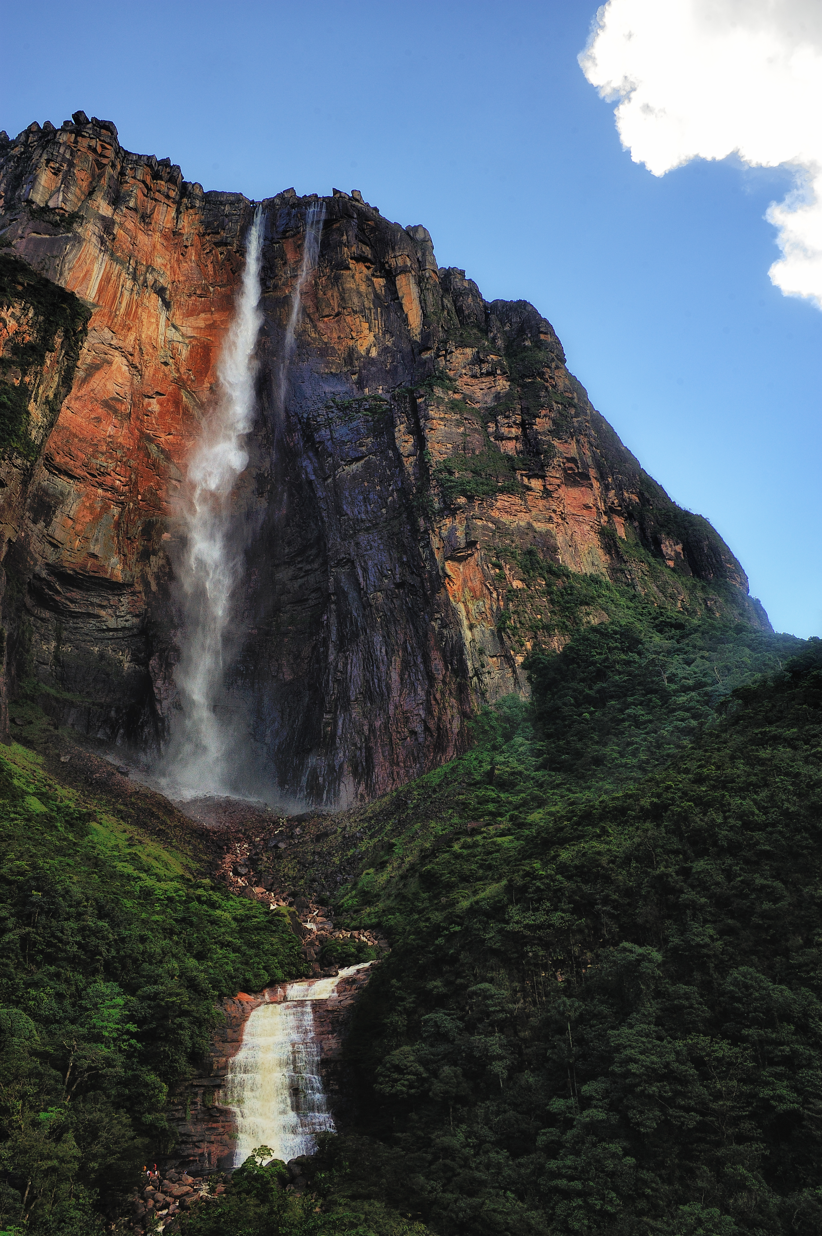
http://www.bing.com/images/search?q=grand+canyon&FORM=HDRSC2#view=detail&id=F8A5930B16677707CC8C5160544C633C9934B2B7&selectedIndex=3
Colorado River. The guide had explained to me that starting 5 to 6 millon years ago, the canyon had been carved out by the Colorado river. Through this time, the river had formed the canyons various and unique dips and crevices. I had been told that this canyon had always been said to be 6 million years old untill recent studies which suggests about a 16 to 17 million years old which would have both been durng Cenozoic Era. There is still much to figure out and to learn from this unique land region. If you wish to visit this location, be sure to bring a camera to capture the moments and to take the skywalk to get an amazing view over this amazing landscape region.
Subscribe to:
Comments (Atom)
